When J. T. Stewart saw it in 1858, it was a very dark brown colour, the water having seeped through thousands of acres of forest-clad soil. It was 300 metres wide (rather than today's average of about 150), and was shallower and slower flowing. Today's riverbed is more than three metres below that of 1935, largely because of the extraction of shingle. Extensive scouring of the banks is a consequence, so shingle extraction is being discouraged.
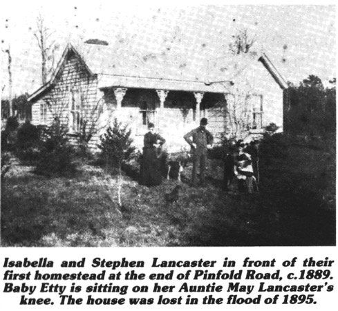
From the earliest days, the Manawatu River was a major influence on the lives of the settlers on the Fitzherbert land. Although the problem of communication with the main source of supply in Palmerston North was solved with the opening of the first Fitzherbert Bridge in 1878 and with gradual improvements in roading, one serious problem — flooding — has always remained for those with property on the river flats. Four large floods before the turn of the century (1880, 1892, 1895, 1897) caused a great deal of erosion of the riverbanks, losses of stock, and damage to the Fitzherbert Bridge. The S. R. Lancaster family lost their home and orchard in 1895. In 1925 the Durden farm lost ten acres, and over the years, Andersons' has lost many acres as the river creeps inexorably towards the school.
In 1913 the Palmerston North Kairanga River Board was established with J. Kyle as chairman, and J. R. Forster-Pratt and F. J. Nathan as two of the members. Its area extended to half a mile above the school, with another Board beyond that. The settlers petitioned the River Board many times but the reply was always to raise a loan and protect themselves. The policy was to use the Fitzherbert East flats as a flood spillway to save the city.
It was not till an act of Parliament in 1941 enabled whole Catchment areas to form unified control that the Manawatu Catchment Board be- came responsible for the area.
This signalled a change of protection procedure. Previously, logs had been rammed into the river bed at angles to the river flow from a punt. Totara beams which had been salvaged from the river were fastened to the logs. These groynes did give a large measure of control, but attracted enormous amounts of debris at flood time, and required extensive maintenance. The new Catchment Board removed the groynes but continued planting willows and poplars, scarfing them and laying them downstream as a living mat. A more expensive alternative, reserved for crucial locations, was battering the bank to a 2:1 slope and covering it with rock from one of the Board's two quarries or with broken concrete.
"Floods" (defined as higher than 9' at the Fitzherbert Bridge) have been 38 in number between 1902 and 1988. The really big ones — over 19' — came in 1880, 1892, 1902, 1906, 1941, 1953 and 1965. Today, farmers receive telephone warnings if the level at Fitzherbert Bridge exceeds nine feet.
