It is difficult for us today to envisage those early roads: unsealed and undrained, narrow and deeply rutted, impassable in wet weather when the predominantly clay soils turned to mud. The earliest cuts were just that — narrow swathes through tall totara stands. Sir James Prendergast, the owner of extensive tracts of Fitzherbert land, was asked in 1887 to fell two to three chains of forest from the road onto his property "to allow the light and wind to act upon the swamp for the benefit of the road". Traveling at night would be a frightening experience for all but the hardiest as the primeval forest loomed darkly over the road. Even after the roadside trees had been felled — by 1890 — their stumps and shattered trunks would appear as gravestones in the misty dark.
Perhaps because the road improvements were not being accomplished quickly enough, the settlers broke away from the Manawatu Road Board and set up their own independent organisation, the Fitzherbert Road Board, on 2 September 1889. Chairman was J. R. Forster-Pratt, and members were Lionel Wallis (Fitzherbert East), James Mowlem, and W. S. Stallard (Tiritea), and F. Caldwell. These five "wardens" met for the first time at S. Greer's home on the Old West Road on 17 October 1889. The complete series of minutes of their deliberations exist still and are held in the archives of the Palmerston North City Council.
Stanley Bruce, an engineer, pioneered the roading system in the area until the Fitzherbert Road Board rejoined the Manawatu Road Board to form the Kairanga County Council, which first met on 14 May 1902.
The pioneers in the years before World War I had only these basics for road construction and maintenance: horse and cart, shovel, wheelbarrow and pick axe, and their prime material was river gravel or "metal". Metal pits were opened as near to the roads as possible to save cartage from the river, and river and stream beds were quarried where convenient.
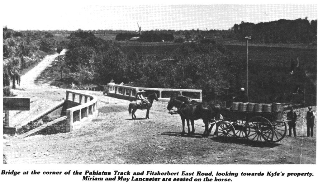
At the foot of Bryant's Hill, (in what is now Moonshine Valley), contractors extracted from pits above and below the road, and from the stream bed. Another pit was on a small county reserve overlooking the swamp opposite the Kyle proper- ty. Others were at the foot of the Pahiatua Track and north of the School at the foot of the hill facing the road on the Woodley (later Pettigrew) farm.
When the motor lorry was introduced in the 1920s, the Manawatu River became the chief source of road metal, and huge quantities were taken to meet the demands of the reconstruction and realignment work of that decade. A pit on the Gosling farm at the end of Staces Road had a face of 10-12 feet of good quality metal, but this source was lost when the Catchment Board opened a river cut there. River beaches at the eastern end of the Anderson farm and at the end of Orrs Road were also used. Thousands of tons from the pit on the Woodley farm were used in the reconstruction of the main road from Orrs Road to the Pahiatua Track in the 1950s.
In the earliest days — 1878-1900 — before all farms had been properly fenced, the minutes of the Fitzherbert Road Board are filled with complaints of serious damage being done to the side drains and the road surface by cattle being allowed to roam.
In those days, a trip into town was a major expedition, probably undertaken once a month with the horse and trap, coming back laden with sacks of flour and sugar. Even in 1906, a newspaper advertisement for a concert and dance at the Fitzherbert East Hall, beginning at 8 pm, advises that transport will leave the Post Office at 7 pm — a far cry from the 10-minute journey of today!
Jack Woodley recounts the story of Jim Woods taking his horse and dray to Awapuni for one and a half tons of chaff — an all-day trip of about 18miles, a long trek for heavy horses at a walking pace. At the bottom of Summerhill Drive still stands the concrete water trough where horses were refreshed before they tackled the long drag up onto Barber's Flat. To improve the journey for the horses also, the roads were engineered so as to avoid steep slopes — hence the frequent meanderings of the main road. These loops, excised from the route in the reconstructions of 1921-24 and 1954, can be seen most clearly in the gullies between Bryant's Hill and the Forster-Pratt corner and on the eastern hump of Bryant's Hill itself. One gully has just been bulldozed out of existence in preparation for the Pacific International College.

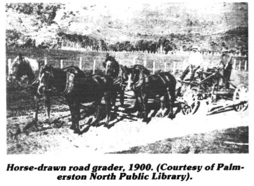
By 1925, Kairanga County had a good system of well-engineered and metalled roads. The area had its own road maintenance headquarters opposite the school on a five-acre reserve bought from Richard Scott. Here grazed three Clydesdales, and Jim Woods lived in the roadman's house. He and his workmate, Arthur Lawrence, had a beat stretch- ing from Orrs Road to Barber's Flat and up to the top of the Pahiatua Track, and took in Staces and Pinfold Roads. They graded the surfaces regularly with a light but effective horse grader carted metal, filled in potholes, and cleaned out drains.
Traffic was comparatively light before 1920 and Jim and Arthur were able to keep the roads in good repair. Three clear tracks were evident on the road surface: the centre one beaten out by the shod hooves of the horses drawing their loads of milk to the factory and the cans of whey and hot water home, and the two outer ones ground smooth by the metal wheels of the carts. Except when the stock was being driven, more dust was circulated by the wind than by the traffic. The Evening Standard in 1902 reported that 100,000 sheep and 20,000 cattle used the Pahiatua Track. Fortunately, large-scale droving is no longer encountered on the area's roads.

The first motor car appeared in Palmerston North in August, 1902, but cars were a rarity on the country roads prior to 1914. In 1905, it was judged newsworthy that the 5hp Oldsmobile of E.Schwarz went over the Range road to Woodville and returned successfully, even though the going was rough.
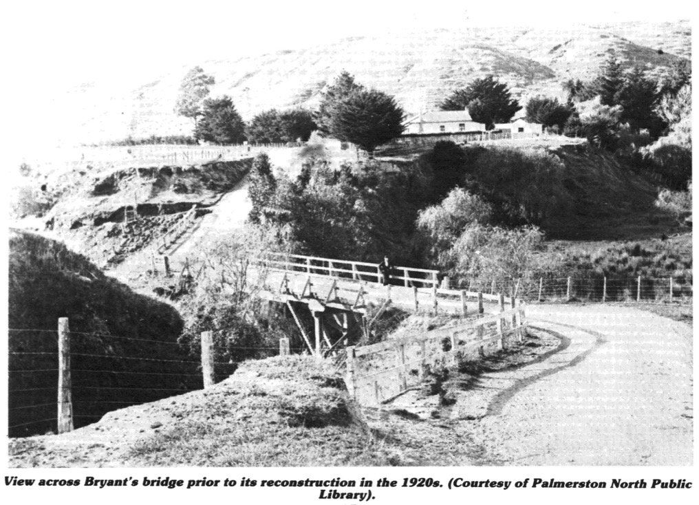
Increasing motor traffic by 1920 necessitated many improvements to the roads. A straightening operation began in 1922 with Mr. Bambery, using horses, plough and scoop, under contract to the Kairanga County Council. However, the cuttings proved beyond his resources and he went bankrupt. The job was finished by other contractors. Most of the hairpin bends were taken out, and wooden culverts were replaced by concrete ones. Bryant's bridge was rebuilt over the old one.
Bryant's Hill was straightened and new bridges were constructed over Lankshear's creek and the school creek. In the 1930s depression, relief workers helped in cutting off corners with picks and shovels and in clearing out the larger drains along the main road.
With increasing mechanisation of road maintenance, the three Clydesdales across from the school were pensioned off in the mid-thirties and a Relay tip truck with a three-yard capacity took over their duties of metal carting and road grading. Edgar Brungar drove the truck and Dick Tate assisted him. They could load three yards of metal with shovels in a quarter of an hour from Orrs Road beach, which by then was the only source of metal. They were followed by Henry Jensen and Joe Mitchell.
There was further reconstruction from 1954, together with the extension of the tar sealing. The only stretch of tar seal before 1945 was an experimental strip by Barber's Engineering works, but by 1963 the whole of the main road between the Fitzherbert Bridge and the Gorge had been sealed. This operation was made possible by a subsidy from the National Roads Board (successor in 1954 to the Main Highways Board). As a by-pass of Palmerston North, the main road through Aokautere was for a time designated as a State Highway (57A). Maintenance became centralised at Awapuni, the local staff became redundant and the house passed into private ownership. The five-acre reserve of the Clydesdales reverted to the Poison farm.
After 1963, attention moved to the Pahiatua Track. It had been carefully maintained for many years because slips and earthworks frequently closed the Gorge Road, but many hairpin bends remained. Many of these were removed, and a new bridge was built to replace the old wooden one which could not take the loads of modern trucks. The Track reconstruction was completed in 1975, by which time all feeder roads to the main road had also been sealed, except for the upper part of Forest Hill Road.
One feature of earlier road maps deserves a mention here: a route to Aokautere via Cliff Road, starting at the eastern end of the Fitzherbert Bridge. In 1897, a group of settlers convinced the Road Board that a shorter route between the Bridge and School was possible and desirable via the cliffs overlooking the river. Strips of land between Cliff Road and Petersens Road were ac- quired and the road was metalled. But it ran into trouble quickly. The river ate into the cliffs and portions of the road collapsed. An Evening Standard report of 30 August 1905 recounts that the Cliff Road route had just been reopened and that the settlers considered the river unlikely to do any further damage because a solid wall of road metal had been constructed.
Alas! Two years later, in 1907, Mrs. Etty Lancaster with her gig and Mr. Wallis on his dray, had just passed over the road when the cliff gave way. Stephen Lancaster and his wife traveling behind had a lucky escape. They had to retrace their steps and go home by the more circuitous route. That was the end of the road. No further efforts were made to reopen it, and if, today, you travel along Cliff Road you meet the Observatory, and beyond it, a steep drop into the river far below.
In recent years, the main road through Aokautere has become used increasingly, in conjunction with Old West Road, as a bypass for traffic from Levin and Wellington to Hawkes Bay. This greater volume of through traffic, and the more intensive subdivision of Aokautere land for residential purposes, are hardly compatible, but no further bypass plans have been mooted, and it is hard to see anything other than cosmetic improvements being made to reduce the many traffic hazards that exist between the Forster-Pratt corner and the Aokautere School. As for the rest of the roading, the foundations laid by the early settlers have been judged good enough. Indeed, an original settler returning in 1989 would see little difference in the network itself — and would find the vast improvements in surface, width, and straightness all being considered quite inadequate for the next decade, let alone the next century.
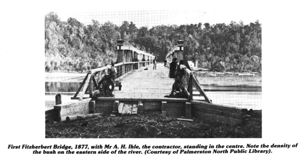
Parts of the Fitzherbert district having been surveyed and sold to intending settlers by 1875, there was considerable pressure for the construction of a bridge to provide access to the district. Although the initial intention had been for a bridge at the end of Fitzroy Street, it was decided in 1875 to cross the river at the end of the newly constructed Fitzherbert Street (now Fitzherbert Avenue). The contract was let in 1876 to A. H. Ihle, a Norwegian settler, who completed the structure in August 1877, six months ahead of schedule. The bridge, consisting of seven 85-foot truss spans, and approaches to give a total length of 805 feet, cost about £7000. Because the contract did not include earthworks at the approaches, the bridge could not be used by vehicles until 1878.
Floods of 1880, 1895, and 1897 caused major damage to the bridge and its approaches, particularly at the southern end. In 1898, the southern span was replaced, and damaged wooden piles were replaced by concrete-filled cast iron, the re- pairs costing nearly as much as the original bridge. Another great flood in 1902 again washed away the road and approach deck at the southern end, and severed the water main from Tiritea, necessitating further extensive repair work.
From 1905 there was agitation for the construction of a second bridge at the end of Scandia Street (now Albert Street), possibly encouraged by the first Ashhurst bridge having been made unusable by floods, and by the collapse of Cliff Road. The question of the Aokautere-Hokowhitu bridge has resurfaced at intervals since, as the following excerpts from the Evening Standard show. "1908: Mr. K. S. Abraham said that when he first came to the district, one of the first things that struck him was the necessity of a means of communication between this district and Pahiatua. The road over the ranges had been completed and he looked upon the bridge as a natural concomitant. They had no idea of the amount of stock that came over from one district to the other. The Gorge road was not to be depended on and he thought the council should take the matter in hand. All the stock auctioneers in this district were in favour of it. It would materially benefit the stock business with that town."
"1919: Mr. Lancaster said, regarding his work as a County Councillor, he had always tried to do his best and had striven to get a bridge over the river at Aokautere . . . They had collected £8,000 and the Government estimate of its cost has been only £7,000. In the next 12 months, the Borough Council would be persuaded to undertake the work .. . They had, however, encountered unreasonable opposition from the Minister, the Hon. R. McKenzie. Yet another effort was being made, when the war put an end to its prospects. He hoped, however, that his successor in the Council would keep at it, and he believed that their wishes would be granted."
The need for the Hokowhitu bridge was reduced by the opening of a new Ashhurst bridge in 1909, and although the issue was revived briefly at the time of the development of the Petersens Road settlement in the 1960s, nothing further has been done. The Fitzherbert Bridge has been completely rebuilt twice (in 1933-4 and in 1986-7), and it seems likely that developments at Massey University, the Fitzherbert Science Centres, and Linton will continue to place greater pressure on an additional river crossing downstream from the present bridge, rather than in the direction of Aokautere.
In spite of the Fitzherbert Bridge, it was commonplace for many years for the Fitzherbert East settlers to reach Palmerston North by fording the river at the end of Staces, Pinfold, or Petersens Roads. Fording was still a regular practice in the 1920s, but was occasionally hazardous, as the account below indicates.
MAROONED IN RIVER
(article in the Evening Standard, 2 March 1923)
A number of people who attended the dance at Aokautere last night had an experience at once dangerous and distressing in the extreme. This morning, two drowned horses tangled in the harness of an express are partly submerged in the rapids of the Manawatu River and a number of young ladies are resting in bed thankful to be alive and physically unhurt.
The circumstances as gleaned from various sources this morning by a Standard reporter are these. Yesterday evening a dance was held at Aokautere as a wind-up to the sports meeting and a party was driven out from town in a three-horse brake by Mr. W. Scott of Aokautere. The route taken necessitated crossing the Manawatu River at a ford at the foot of Scandia Street (now Albert Street). The river being fairly low, this was accomplished in safety. Shortly after midnight, the return journey was commenced by the same route. Mr. Walter Scott again held the ribbons and the party comprised Misses E. and M. Brown, sisters of Mr. W. Brown of Aokautere, who are living in Rolleston Street, Miss Tims, of Cook Street, Miss Stewart and Miss Johnston, Mr. Val Knight, Mr Alan Scott (brother of the driver), Mr. Barling and Mr. Fleming, of Palmerston North.
The night was particularly dark but arrived at the river, the party were able to see the shining surface distinctly and the ladies at least realised that, in the interval, the volume of water had swollen considerably. It was decided, however, to cross by this ford, and the driver urged his horses into the river. By the time the horses were halfway across, they were floundering on the precarious footing of river boulders. Buffeted by the remorseless current, they were helpless. A t length, the vehicle, tilting sharply to one side, came to a full stop and the two-wheel horses drowned in the harness, while the driver desperately strove to extricate them. The leader burst the traces and got clear away. In the meantime, the water was rushing across the greater part of the vehicle and the passengers clung to the higher and projecting side in a most uncertain frame of mind.
The darkness was intense and it appeared that if anything the river was rising. In any case, it was frightfully cold and the idea of spending a number of hours of the night half submerged in the freezing waters of the Manawatu River, clinging to a damaged express, was abhorrent to every member. To gain freedom of movement, the party divested themselves of surplus clothing, and Barling, Scott and Fleming set out for shore with the idea of establishing communication by rope or other means with those marooned on the express. That these young men were not lacking in purpose is demonstrated by the fact that they did gain the shore, and judging by the wet marks on the bank this morning, the river was running high. A man in a whare near the metal pit was roused from his sleep and the party was directed to Mr. E. Gould's house in Scandia Street, where a telephone was obtainable. The police were communicated with and also Mr Smith's home in Aokautere and neighbours were roused. The party reinforced by hastily dressed residents returned to the scene and a few moments later Constable Gow arrived on a motorcycle, carrying a bathing costume with him. Ropes were procured and swimmers set out for the ex- press, but in one case the rope broke, the swimmer emerged a hundred yards further down. It was apparent that such means of communication were out of the question. Another man caught the leader and rode the horse out to near the express, but was lucky to get back himself.
On the opposite bank, another party had already collected, and Mr Hoperoft, of Aokautere, made an effort to reach the vehicle, but he was washed hundreds of yards away and crawled out of the river in an exhausted condition (he had broken several ribs when he hit a submerged log). However, it soon became clear that the river had ceased rising and that the express was jammed firm, so that it was a question of whether the ladies could stand the exposure until morning.
With very commendable thought, Mrs. Gould, Mrs. Franks and Mrs. Robin returned to their houses in Scandia Street and fetched the concomitants for a meal and tea. The two latter-mentioned ladies are newly arrived in the Dominion from the Old Country and a flooded river adventure at 2 o'clock in the morning held for them an acceptable spice of romance and they lent their aid with vim. A roaring fire was made and those on shore kept warm in the blaze.
At daylight, a team of three heavy horses was harnessed into a metal dray and urged into the stream. The pitiful animals breasted the current stream and at length, the dray was got into position by which, though with some difficulty, the ladies, cramped with the cold and distressed with their perilous experience, could be transferred and then ferried ashore.
It was about 5.30 o'clock this morning that a weirdly attired party sat around a fire and enjoyed the warmth and the tea thoughtfully prepared by the three ladies.
Yet even after Jack Woodley arrived in Aokautere in 1925, folk were still fording. He remembers Mr. Pinfold taking pigs across with his spring cart and horse. For many years, Mr. Petersen had a punt at the end of Pinfold Road and obliged by carrying people across to Ruahine Street, near the present Catchment Board office. Jack once bought some cows at a sale in lower Albert Street and, to save them the long drive around the road, he swam them across, coming out at Petersen's farm. He was up to his armpits at the deepest part and enjoyed the experience!
Later, he made a crossing at the end of Pinfold Road one evening, hoping that it would be easier than cycling the hills. He was lucky. The River Board was working in the area and had left a large totara log right across the river . . . "With my bike on my shoulder, I did not even have to take my shoes off or get wet. I did not chance my luck a second time; the fight through the lupins on both sides of the river made it hardly worthwhile."
Davis Hoperoft, yarning while folks waltzed at the Centennial Ball, told how in the 1930s he cycled to Boys' High via the river in summer, taking off his pants and carrying his bike on his shoulder for the water crossing. Then on with his black shorts and socks and off to school.